March D, Alós J, Cabanellas-Reboredo M, Infantes E, Jordi A, Palmer M
Estuarine, Coastal and Shelf Science 131: 206-212
Publication year: 2013

ABSTRACT

We implement a Bayesian spatial approach to predict and map the probability of occurrence of seagrass Posidonia oceanica at high spatial resolution based environmental variables. We found that depth, near-bottom orbital velocities and a spectral pattern of Landsat imagery were relevant environmental variables, although there was no effect of slope or water residence time.

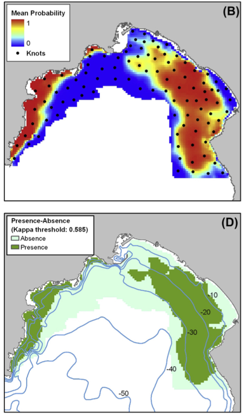
We generated a data inventory of P. oceanica samples at Palma Bay, NW Mediterranean, from three main sources: side scan sonar, aerial imagery and a customized drop-camera system. A hierarchical Bayesian spatial model for non-Gaussian data was used to relate presence-absence data of P. oceanica with environmental variables in the presence of spatial autocorrelation (SA).

A spatial dimension reduction method, the predictive process approach, was implemented to overcome computational constraints for moderately large datasets. Our results suggest that incorporating spatial random effects removes SA from the residuals and improves model fit compared to non-spatial regression models. The main products of this work were probability and uncertainty model maps, which could benefit seagrass management and the assessment of the ecological status of seagrass meadows.

doi.org/10.1016/j.ecss.2013.08.009

Highlights

  • Bayesian spatial approach used to predict and map the probability of occurrence of Posidonia oceanica.
  • Depth, near-bottom orbital velocities, and a spectral pattern of Landsat imagery were relevant environmental variables.
  • Data inventory generated from three sources: side scan sonar, aerial imagery, and customized drop-camera system
  • Hierarchical Bayesian spatial model used to relate presence-absence data with environmental variables, and predictive process approach implemented to overcome computational constraints for moderately large datasets.
Mapping of Posidonia oceanica with Bayesian spatial approach for predicting seagrass occurrence

Related articles

32. Novel approach for large-scale monitoring of submerged aquatic vegetation – a nationwide example from Sweden

Journal Papers
Huber S, Hansen L, Nielsen L, Rasmussen M, Sølvsteen J, Berglund J, von Friesen CP, Danbolt M, Envall M, Infantes E, Moksnes P-O
Integrated Environmental Assessment and Management, 18(4): 909-920. DOI: 10.1002/ieam.4493
Publication year: 2021
Probabilistic mapping of seagrass

10. Probabilistic mapping of Posidonia oceanica cover: a Bayesian geostatistical analysis of seabed images

Journal Papers
March D, Alos J, Cabanellas-Reboredo M, Infantes E, Palmer M
Aquatic Botany 106: 14-19
Publication year: 2013
Water residence time controls the feedback between seagrass, sediment and light: implications for restoration

20. Water residence time controls the feedback between seagrass, sediment and light: implications for restoration

Journal Papers
Adams M, Ghisalberti M, Lowe R, Callaghan DP, Baird M, Infantes E, O'Brien K
Advances in Water Resources, 117: 14-26
Publication year: 2018
Management and restoration of eelgrass in Sweden

Management and restoration of eelgrass in Sweden - Ecological, legal and economic background

Reports
Moksnes P-O, Gipperth L, Eriander L, Laas K, Cole S, Infantes E
Swedish Agency for Marine and Water Management (HAVs). Report 2016:8, 148 pages, ISBN 978-91-87967-16-0
Publication year: 2016
Seedlings of eelgrass Zostera marina

12. Eelgrass (Zostera marina L.) restoration methods on the west coast of Sweden using seeds

Journal Papers
Infantes E, Eriander L, Moksnes P-O
Marine Ecology Progress Series 546: 31-45
Publication year: 2016