Huber S, Hansen L, Nielsen L, Rasmussen M, Sølvsteen J, Berglund J, von Friesen CP, Danbolt M, Envall M, Infantes E, Moksnes P-O
Integrated Environmental Assessment and Management, 18(4): 909-920. DOI: 10.1002/ieam.4493
Publication year: 2021

Abstract

According to the EU Habitats directive, the Water Framework Directive and the Marine Strategy Framework Directive, member states are required to map, monitor and evaluate changes in quality and areal distribution of different marine habitats and biotopes to protect more effectively the marine environment. Submerged aquatic vegetation (SAV) is one of the key indicators of ecological status of coastal ecosystems, and therefore widely used in reporting related to these directives.

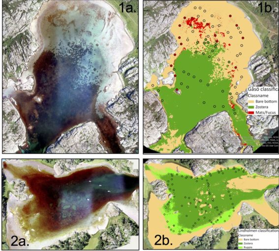
Environmental monitoring of the areal distribution of SAV is lacking in Sweden, due to the challenges of large-scale monitoring using traditional small-scale methods. In order to address this gap, in 2020, we embarked on a project to combine Copernicus Sentinel-2 satellite imagery, novel machine learning (ML) techniques and advanced data processing into a cloud-based web-application that enables users to create up-to-date SAV classifications. At the same time, the approach was used to derive the first high-resolution SAV map for the entire coastline of Sweden. In total an area of 1,550 km2 was mapped as SAV.

Quantitative evaluation of the accuracy of the classification using independent field data from three different regions along the Swedish coast showed relative high accuracy within the more shallow areas of the classification, particularly in areas with high water clarity (average total accuracy per region 0.60-0.77). However, the classification missed large proportions of vegetation growing in deeper water (on average 31-50%) and performed poorer in areas with fragmented or mixed vegetation and poor water quality, challenges that should be addressed in the development of the mapping methods towards integration into monitoring frameworks such as the EU directives.

In this article, we present the results of the first satellite-derived SAV classification for the entire Swedish coast and show the implementation of a cloud-based SAV mapping application (prototype) developed in the frame of the project.

DOI: 10.1002/ieam.4493

Highlights

  • EU directives require member states to map, monitor, and evaluate marine habitats to protect the marine environment.
  • Submerged aquatic vegetation (SAV) is a key indicator of ecological status, but monitoring of its areal distribution in Sweden is lacking due to challenges in traditional methods.
  • A project in 2020 combined Sentinel-2 satellite imagery, machine learning techniques, and data processing to create the first high-resolution SAV map for the entire coastline of Sweden.
  • The mapping approach achieved relatively high accuracy in shallow areas with high water clarity, but missed significant portions of vegetation in deeper water and performed worse in areas with poor water quality or mixed vegetation, which need to be addressed in future developments for integration into monitoring frameworks.

Related articles

Probabilistic mapping of seagrass

10. Probabilistic mapping of Posidonia oceanica cover: a Bayesian geostatistical analysis of seabed images

Journal Papers
March D, Alos J, Cabanellas-Reboredo M, Infantes E, Palmer M
Aquatic Botany 106: 14-19
Publication year: 2013
Bayesian

8. A Bayesian spatial approach for predicting seagrass occurrence

Journal Papers
March D, Alós J, Cabanellas-Reboredo M, Infantes E, Jordi A, Palmer M
Estuarine, Coastal and Shelf Science 131: 206-212
Publication year: 2013
Dugong reproductive behaviour in Koh Libong, Thailand: observations using drones

23. Dugong reproductive behaviour in Koh Libong, Thailand: observations using drones

Journal Papers
Infantes E, Cossa D, Stankovik M, Panyawai J, Tuntiprapas P, Daochai C, Prathep A.
Aquatic mammals, 46(6): 603-608
Publication year: 2020
An automated work-flow for pinniped surveys: a new tool for monitoring population dynamics

37. An automated work-flow for pinniped surveys: a new tool for monitoring population dynamics

Journal Papers
Infantes E, Carroll D, Silva WTAK, Harkonen T, Edwards S, Harding KC
Frontiers in Ecology and Evolution, 10:905309. doi: 10.3389/fevo.2022.905309
Publication year: 2022